by Giuseppe Strappa, Matteo Ieva, Marina Dimatteo
in : G.Strappa, M.Ieva, M.A.Di Matteo, La città come organismo. Lettura di Trani alle diverse scale, Bari 2003.
The main task of this book is to demonstrate a method of reading built landscape based on the fundamental assumptions that the different reading scale of built landscape (building, aggregate, urban, territorial scale) are linked between themselves by the notions of organism and type and that the tools of typological-processual analysis are not subordinated but complementary to the traditional tools of reading city and territory such as the urban history or archaeology.
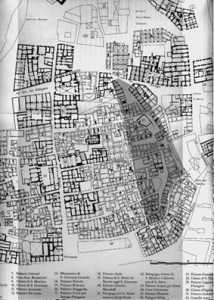
At this regard the case study of Trani (see tav 2 pag. 68) seems particularly suited for the task as few evidences of the urban form is known before the IX century and any formation process regarding the original settlement type and fabric has to be investigated mostly trough typological interpretations.
Even the research about Trani is still in progress, we believe useful to propose some working hypothesis (see tavv. 9a,9b,10 at pages 76,77) about the ancient origin of the medieval structure of the town inside the Longobard city walls of the XI century and of Federician ones of XIII century. A matrix possibly derived from the ancient Turenum reported on Tabula Peutingeriana.
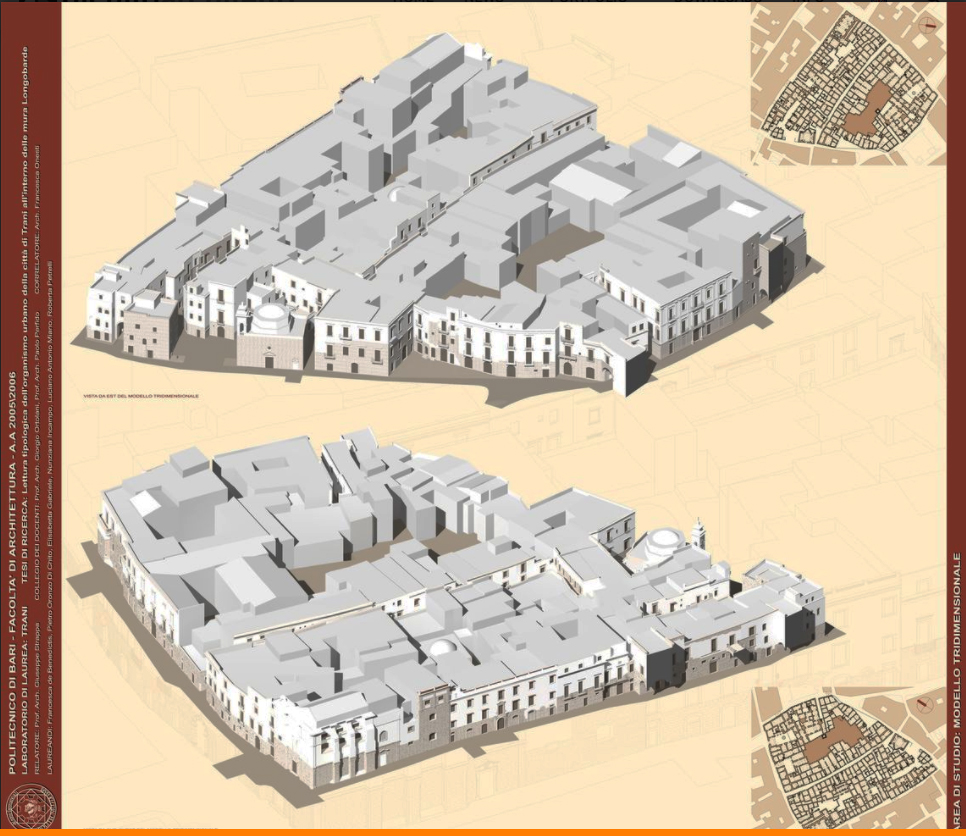
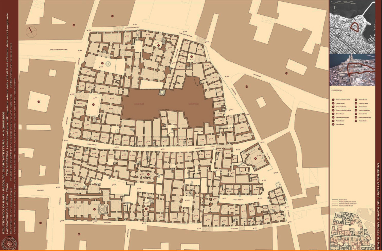
The central area of the old town, in fact, can be regarded as planted on a matrix route (actual via Beltrani) polarised by the specialised area of the Cathedral and the Episcopal Palace, which organises, with remarkable regularity in dimensions and pertinent strips, an orthogonal grid of routes (see tav.5b at page 71).
A second route, now disappeared and parallel to via Beltrani, whose urban role we will see later, can be recognised as prosecution (now infilled) of the narrow path of actual via Leopardi (Carlone 1981).
The regularity of the urban structure around; a centralising axis and the remarkable differences in the urban aggregates in the south east from the ones in the north west areas, induce us to think, more than a spontaneous hierarchization of the different routes, to some form of original planned grid from which the medieval structure has taken place through a general up-dating of building types and an extensive substitution of special building, but also trough a substantial preservation of the ancient structure of routes, even if conditioned by progressive transformations in the settlements and territorial order, as the formation of the Jewish quarter of La Giudecca, evidently planted on the spontaneous routes linking the coastal viability.
It must be considered that the crisis followed to the fall of Roman Empire of Occident in V century, the gothic war in VI century, the Longobard conquest in the VII one, had as a consequence the decay of most of urban and territorial structure in Apulia and that the reorganisation started in VIII century trough the Longobard gastaldati and, in the following two centuries, Byzantine administration, using tools and scale comparatively modest, must have been founded on the extensive remains of the ancient urban heritage.
The dialectic between planning as result of “critical conscience”, and adaptation as product of “spontaneous conscience” , is so continuos in the relationship between ancient city and late-ancient or middle age transformations, that it is possible to recognise in the different passages a remarkable level of typicality.
Just this typicality allow us to read single phenomenon as part of a more general process of changing of characters in Italian cities.
The cartography employed in the research consists in:
– contemporary and 1873 cadastral maps at 1/1000 scale;
– survey of building structures carried out by Trani Administration in 1989 at 1/200 scale;
– survey of building structures carried out specifically for the research, partially still in progress;
– 1869 IGM (Istituto Geografico Militare) maps at scale 1/50.000 and contemporary (1938 and 1963) IGM maps at scale 1/25.000;
– historical maps.
A chronology derived from documents of historical events compared with transformations in urban form of Trani has been also employed.
The following synthetic description starts from the smaller scale of the building till the territorial scale
BUILDING ORGANISM SCALE
A – BASE BUILDING
The base building of Trani is composed by an aggregate of roughly squared cells of average dimensions ranging from 4 to 6 meters with modular (half o double size) variants. The construction is in local stone for vertical walls with masonry vaulted floor at ground and wooden-beam at successive floors.
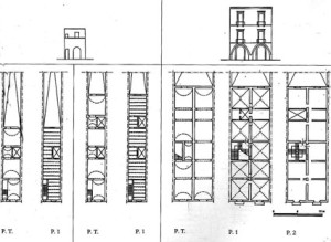
The wide quantity of types in aggregation of cells can be reconducted to two main basic types of houses:
• two cells row houses, with numbers of synchronic variants by position and diachronic variants due to the infill of pertinent area, increasing in highness, specialisation of ground floors, sometimes as loggia mercantile (see fig.7 at page 114 and tav.70 ata page 135). This peculiarly medieval type of housing, largely spread in all northern¬central Italian peninsula, is not so common in Apulia, where it seems imported, at least in its “mature” form trough exchanges with northern areas consequent to Longobard and Federician domination (the exemplary case of the foundation town of Manfredonia can be considered)
• courtyard houses, in which cells are aggregated around a common distribution space originally open. This type, derived from the “consumption” of the roman domus at the end of a long typological process (see tavv. 1,2,3,4 at pages 98-100), is extensively employed in Apulia towns (Bitonto, Polignano, Conversano, Altamura etc.), although with a south east common orientation instead of the usual southward one. The same toponimy of the places (curte from Latin curtis , claustro from claustrum) indicates their ancient direct or indirect origin. From the cadastral maps of Trani is possible to read as those aggregations are often contained within modular enclosure, with the actual different ownership often roughly obtained trough partitions of an original modular one.
Both types can be found, largely transformed,. in the Trani urban fabric: diachronic variants and sometimes multi family fusion (originating thus new types) of old single family houses for the row houses; pseudo row house for the courtyard houses.
A first, important consideration for the reading of the city, can be made observing the diffusion of the different types:
– the first type is individuated at the margin of the central area, outside and inside the Longobard perimeter and in the Federician expansions, with the remarkable exception of an homogeneous aggregate in the S. Martino area (see tav.25 at page 89);
– the second type appears to be concentrated in a roughly squared area with sides of 150, 200 metres.
This consideration allows us to put forward a first hypothesis (which will be supported by other dates) on the structure of the ancient town, occupied by the “substratum” courtyard type and cleared “in negative” by the row houses perimeter. In the S. Martino area we must grant the presence (which also will be supported by other dates) of an extensive open area free from private building in which a tissue based on up-dated types had developed.
B – SPECIAL BUILDING
The first religious buildings, mostly convents and related constructions, are situated along the Longobard perimeter. As usual for building types as monasteries, which require large space to develop, those constructions occupies initially anti polar.positions in relation to urban route (but often nodal in relation to territorial routes) to become, with the expansion of urban organism, urban poles of successive expansions (see tav.79 at page 143).
In XII century appear to be edified:
• westward, the monasteries of S. Paolo and S. Giovanni and the church of S. Giovanni e Paolo
• southward, the church of S.Salvatore (on the route for Andria); the church of S.Andrea and Toma (close to Porta Nova doorway and the route node at the intersection between the carriage coastal road and the route connecting the productive hinterland), with the church of S. Caterina immediately inside the door and the small church of S. Agata in even more central position, but anyway external to the area of orthogonal routes;
• eastward, corresponding to Porta Antica doorway, the nuns convent of S. Trinita, the Ognissanti church and a number of small churches close to the port;
• northward the special complex of the Chiesa Maggiore, church S.Giovanni Evangelista and Palazzo dell’Arcivescovo;
• in even more anti polar position a number of special areas and buildings, most in Colonna peninsula (the churches of S. Antonio, S. Vito, S. Giovanni de Penna, the Jewish cemetery) and close to the route node corresponding to the cross of Flumicellus flood (S. Maria Cavense, SS.Sergio e Bacco, S.Giorgio, S. Maria de Dioniso, S. Trinità, S. Basilio)
• single and remarkable exception to the general anti polar position of special buildings is the monastery and church of S. Martino, situated in the.very centre of the area of regular grid routes. This is not only the oldest monastery in Trani, but its construction must date far before the year 1075 evidenced by documents, as the architectural characters and the building technique employed would rather indicate an origin in X or even IX century (Ronchi, 1988).
The area of the ancient settlement can be derived from the analysis of special building placement: it clashes with the area of regular routes around whose margins, typically, most of special buildings are displaced.
The exception of the site of S. Martino complex confirm the hypothesis of a large public area for the construction of special building available after the fall of central administrative control.
The type of palazzo building must be considered (see tavv. from page 142 to158), in general, apart from the other special buildings for their close relation to base building. In Trani, in particular, palace type has a late formation in XV-XVI century, with large construction obtained by fusion of a number of cells of base building on ‘the main matrix routes polarised by special areas of great civil and religious value: most in via Beltrani (via Duomo), connecting the nodal area of Porta Nova with the Cathedral and the fair area. Here are first settled the Rogadeo, Palagano, Bonismiro palaces and, later on, the most important palaces of Trani, giving origin to a real “special tissue”, in the same manner of other prosperous maritime cities as Genoa and Venice .
Houses of other important families as de Boctunis, de Cuneo, de Agnete and, again, Palagano also settled in via Ognissanti, connecting the route node in Flumicellus area , trough the Giudecca quarter, to the area of S. Marco church and Caccetta, Sifola, Filangeri palaces.
In the palazzo type individuated in Trani is quite constantly possible to recognise the re-aggregation of cells, originally belonging to single family houses, in a new unitary organism. The unified facades give clear evidence of the intention to form a “rhythmic wall” (Caniggia, 1979), but the irregularity in the distance between windows, often the lack of a true centralising axis and, instead, the recognisable presence of the original dividing lines, indicate the derivations.
The level of typicality of those palaces is very low in comparison with the examples of other areas as the Roman, Florentine or Venetian ones. Only few characters are in common: the aggregate of cells around a common distribution space in which the main stair is placed; the dimensions of the front walls, based on the modules (often double) of the courtyard house from which seams indirectly to be derived.
The origin of via Beltrani palaces, anyway, demonstrate as the area was previously occupied by base building, probably by domus type houses. With increasing social and economic divisions this type has generated both, as in Venice (Maretto, 1986), the palace type and the pseudo row houses, the first as increment, the second as decrement of an originally common pattern of enclosure.
AGGREGATIVE ORGANISM SCALE
To recognise the shape of a possible planned urban structure we need to use, further the analysis based on the route hierarchy and pertinent strip, the notion of tissue as type of aggregate subjected to typical processual transformations, in our case from ancient to middle age city. We need, in other words, to investigate in their typicality the phenomena of “medievalization” of ancient urban fabric. These phenomena are in general mostly related to the public spaces infilling process by private ownership (Caniggia, 1963 and 1976) owing to the decay of administrative control started in late ancient period.
They are distinguished by three constant aspects, present also in our case:
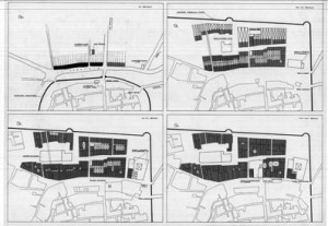
• the deformation of planned orthogonal alignments (see tav.4b at page 70);
• the infill of ancient public spaces, specially if partially opened, trough new special building or new spontaneous base building fabric recognisable for the lack of planning of the related routes (see tav.8 at page 75);
• the formation of non planned fabric along, the spontaneous curvilinear routes connecting the doorway of the wall (see tav.6 at page 74, tav. 22 at page 88 and tav. 30 at page 91).
It is particularly useful the analysis of alignments of masonry structure at ground floor distinguishing:
– orthogonal alignments which could be related to ancient planned structure;
– curvilinear alignments oriented from alignments of planned city which could be related to progressive advancing of buildings front walls as for infill of routes free spaces;
– diagonal alignments opposite to the general orthogonal grid which could indicate new medieval fabric in evidently free spaces.
All those alignments had been recognised in Trani and drowned on tables which demonstrate clearly:
• the presence of an orthogonal grid of wall alignments in the inner medieval town which, for exactitude and constancy inside the supposed ancient city, can’t be other than planned;
• the presence of orthogonal routes “medievalized” trough the advancing or deformation of wall front with particularly extensive and evident infill in the two actual roads of vico Santo Nome e via Beltrani, which can be related, for dimensions and role inside the urban fabric as the two main access routes to the ancient city: the first on the axis of via praetoria, and the second as the other main route on the counteraxis of via principalis as in typical roman planned city. Those road, from which planned routes are originated, must had a behaviour as matrix road in middle age transformations, originating different aggregates owing to the different orientation of the original courtyard houses:
per strigas on via S. Martino, via Leopardi, via Sinagoga
per scamna on via Carlo d’Angiò, via S. Giovanni, via Romito, not by case transversally connected by vico (or narrow road) S.Agata e vico S. Gaetano).
Another important, even if secondary axis, was on the alignment of actual via Leopardi. This route could have had a connecting role comparable to that of via quintana in roman pattern.
The “medievalization” process appear to be confirmed from the presence and continuity of many internal wall alignments, even in the extensive transformations occurred. The unusual proximity @ of those wall alignments to the outer walls, mainly in correspondence of block corners, can’t be in fact explained neither as constructive nor distributive anomalies.
• the presence of a large public area occupied by structures as peristilia or portici, in the site of the S. Martino complex proved, resuming what previously asserted, by:
1) the base building types employed in edification (row house in courtyard type contest);
2) the special building types employed in edification (the now disappeared monastery, individuating a typical anti polar type);
3) the diagonal alignments corresponding to new unplanned fabric
• the position of the doorway polarising unplanned perimeter curvilinear routes (Caniggia, 1976)
URBAN ORGANISM SCALE
From the previous considerations, linking together in an organism the different base and special aggregate individuated in Trani, it is possible to propose a well-founded hypothesis about an ancient matrix of the actual town derived from the typical form of roman planning, based on the formation of two main orthogonal axes polarised by the forum area, with base building based on a courtyard house type, in our case lightly less in frontal dimension (16 metres) than the usual half actus , aggregated in “closed” or “opened” series and separated by ambitus. An original nearly squared city wall perimeter, measuring about 150/200 metre in side, can be argued from the previous considerations.
The city wall thus contained, typically, the higher part of the peninsula and were quite regular in shape and symmetrical on the side of the main access , as usual in roman planned city (see tav.7 at page 74) as Firenze, Genova, Como (Caniggia, 1976; Strappa, 1987) while they rotate in the direction of the port in the southern part, perhaps also conditioned by previous routes, orienting the courtyard houses fabric inside .
The ancient city wall corner and the position of the doorways are legible trough the curvilinear routes analysis. This perimeter of original city wall disappeared probably at middle IX century, at the time of Saracen domination over Bari
In the north-eastward side can be supposed both:
– the prosecution outside the perimeter of the actual via S. Martino and via Leopardi routes (now rotate in direction of the commercial area of the port) ;
– the presence of a single central doorway connecting the Giudecca area, in the site of the two main synagogues , at the end of the diagonal route of S. Martino area. The site of this doorway, to which is for the moment impossible to attribute a date, is confirmed by the discovery of a route, now infilled inside a block between via Giudea and vicolo Giudea. The direction of this route, pointing exactly the place of the supposed door, is confirmed from the corresponding alignment of walls in the following block.
Having assumed as matrix the type derived from roman planned town, it remain unsolved the problem of stating to which type of urban organism it can be referred. The term castrum , the dimension of which are not anyway reached , related to Trani in documents from IX century is in fact employed with the meaning of a fortified settlement which don’t reach the dignity of a civitas..
It is not allowed, also, to relate to other type of roman colonisation towns as the coloniae latinae, far wider in dimensions , neither to coloniae viritanae as the complete list of them (35 in all) is asserted by literary evidences.
An urban pattern, even if of later date , not far different from coloniae maritimae founded first on Tyrrhenian coast and then on the Adriatic ones in II century B.C. could be proposed.
This hypothesis could be supported by the contained dimensions of the original nucleus which must not had exceeded 70 courtyard houses: not far from the small initial size of about 300 farmers with perimeter around 150/200 metres in side of coloniae maritimae . Nevertheless the modest size of public spaces of the latter, consequence of the lack of administrative autonomy, don’t allow too close comparison with Trani, where the forum area seem to had been relatively wide .
Our proposed interpretation of the ancient urban organism had been, anyway, traced on the data deduced from the actual structures referred to some general characters common to roman planned town, leaving unsolved the question if this urban order is the first one or if it has been reached starting from an even precedent settlement .
The reading of urban organism of Trani is still far to be definitive, as it is intelligible from the number of problems still unsolved and for the coexistence, sometimes, of a double hypothesis (as for the access to oriental wall), resolvable probably admitting the diachronicity of two different orders reached in different historical phases. A further evidence of the original ancient pattern of Trani could come from the studies of the level of routes and construction: it seem clear that also in Trani, as for many ancient cities, a general vertical “growth” of road level has occurred, proved by:
• the ground level of many houses, lower then the level of the related route;
• the presence of underground floor when the ground level of houses is higher than the level of the related route;
• the original level of the area of the supposed forum, where the S. Martino church had been founded at an average level two metres lower than the actual road level;
• the construction level of the buildings below the Cathedral: the S. Maria church, probably dating to V century, is founded on the ruins of a previous Early Christian church 130 cm below the level of actual crypt;
• the higher level of via Beltrani, below which recent excavation work has revealed no traces of previous structures, in comparison with the other planned route, which confirm its role of matrix route, typically following a light ridge coming from inland territory.
If we compare the evolution of city wall we can note how the urban structure is the result of a territorial dialectic between inland routes structure and coastal ones, which can be understood reading the built environment at a larger scale.
